Urban Heat Island effect is the phenomenon which occurs when the temperature of any urban area is more than the nearest rural area. Urbanization has one of the biggest contributions in temperature rise. Thus, in this research, the Urban Heat Island effects are assessed utilizing GIS and remote sensing to understand the change of Land Surface Temperature with the change of Land Cover over years.
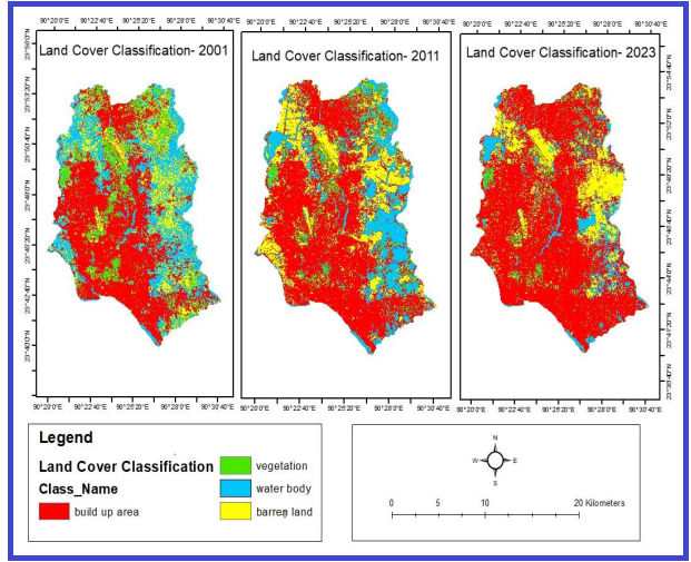
Dhaka City has been chosen to host the study to evaluate the temperature change over years with the change of land cover. In this study, Landsat images from the years 2001, 2011 and 2023 are used. For the three years, land cover is classified using the support vector machine technique, and the classification’s precision is assessed using the Cohen kappa score.
| Report Title : | Urban Heat Island Effect Analysis Using Integrated Geospatial. |
| University Name : | Bangladesh University of Professionals |
| Submitted To : | Israt Jahan |
| Submitted By : | Tazina Mim |
| Total Page : | 58 |
The principal causes of this temperature differential, which is most measurable in the evening and at night, are urban development and human activity. Bangladesh is a developing country. The urbanization process is very fast here. In big cities here increasing temperature is felt compared to nearby rural area. Already we are facing heat waves in summer.
In short, There are several reasons behind this. Reasons for what urban heat island creates are basically urbanization for what extensive concrete building, infrastructure, roads absorb heat during night and release at night and lead to elevated temperature. Reduced vegetation in urban area also contributes here cause the less the vegetation, the less the shade, evaporation rate and the less the evapotranspiration.
Problem Statement
This increase of temperature is being a great concern because the temperature of the urban area is significantly higher than the nearest rural areas. The increasing temperature is contributing to the global climate change issue. Urban heat island effect causes heat related health risk. Especially the elderly, children and people with health issues suffer the most. On June 7, 24 students fell sick because of recent heat wave in Dhaka.
Moreover, Energy consumption and greenhouse gas emissions. It also affects the urban infrastructure by affecting structural integrity. Also, it stresses the electricity supply and also it increases the maintenance cost and reduce the resilience and impacts the local climate. The more land is converting to build up area the more the Land Surface Temperature is increasing.
Research Question
- In which extent Land Cover is changing over time in Dhaka city?
- Is there any relationship between Land Use Land Cover change and Land Surface Temperature change in Dhaka city over time?
- Is urbanization have any impact on the temperature rise in Dhaka city?
Research Objectives
- To identify the UHI effect of Dhaka city using integrated geospatial technique.
- To determine the Land Cover change and Land Surface Temperature change and greenness using geospatial tool LULC, NDVI and LST to understand the reason of UHI effect.
- To determine the UHI effect in Dhaka city over time from (2001-2023)
Outline of the Report
Introduction Part
Background of the Study, Problem Statement, Rationale of the Study, Research Question, Research Objectives, Outline of the Thesis.
Literature Review Part
Local and international articles relevant to the thesis’s topic are reviewed and summarized in this section.
Conceptual framework Part
This chapter outlines the abstract representation of the research study, which corresponds to the research study objective that guides the gathering and analysis of data.
Methodology Part
This chapter offers in depth information regarding data gathering and data analysis methods. Also, this describes how the research and analysis is done.
Results & Discussion Part
Under this section, the results of the data analysis are interpreted and elaborately described.
Recommendations & Conclusions Part
This chapter includes some suggestions for minimizing the issues.
Implications and Recommendations
Mitigation Strategies
The following techniques can be adopted to reduce the impact of Urban Heat Island (UHI) in Dhaka City:
- Increase in Urban Greenery: Roof gardens, vertical gardens, and promotion of planting trees on the street.
- Green Construction Code: Applying building rules that ensures the use of energy-efficient and climate-friendly materials.
- Cool Roof and Pavement Technology: Reduce heat absorption by using reflective surface on the streets and roofs.
- Urban Plan Reforms: To ensure that the green belt and park maintain in the new project.
- Public Awareness Program: Encouraging citizens to take sustainable habits, such as roofing gardens or energy-efficient cooling.
UHI’s Health Effect
UHI effects have direct and indirect health effects:
- Warm-Related Stress and Stroke: Older, child and pre-existing health problems are the most vulnerable.
- Respiratory Problems: High temperature can increase air pollution, causing asthma and respiratory problems.
- Reduction of Productivity: Urban high temperature affects the student’s attention, employee’s performance and lifestyle.
- Recent Events: On June 7, 24 students in Dhaka became ill during the heat flux – which indicated the urgent requirement of thermal mitigation policy.
Future Research Scope
This study has provided strong data, but further research can be done:
- Greater Time-Series Data: Use long-term UHI trends using satellite images of the 9th or 9th.
- Verification on Land: Real-time observations by setting temperature sensors on schools, hospitals and busy streets.
- Simulation Model: To predict the future UHI effects of various urban growths.
- Comparison with other cities: Comparing the regional UHI pattern compared with Dhaka, Chittagong, Kolkata or Delhi.
Practical Relevance for Students
This thesis is particularly helpful:
- For Geography and Environmental Science Students: Climate research to understand GIS applications.
- Urban Plan for Students: To learn how to change the use of land affecting microclimate.
- For Climate Change Researchers: to identify the role of temperature rise due to urbanization.
- Project Paper Reference: GIS/Remote Sensing Thesis is a complete example of how to structure.
Conclusion
Which is help for us? The identification of UHI effect for Dhaka city will help us to understand the extent of temperature rise and temperature difference between nearest rural area and the main city. Also, the impact on the micro climate will also be determined. To understand the importance of greenness in the city and it will further help the government and urban planning sector to understand how to do the urban planning so that it doesn’t stress the environment.
Finally, In this research it has been found that the build-up area is increasing day by day. Build-up area was 46% on 2001 and it has become 69% on 2023. So, the build-up area is contributing to LST rise over time. From this research finding it can be understood that the increase of build-up area or urbanization is one of the important reasons for Urban Heat Island effect.
Frequently Asked Questions (FAQs)
- Question 01: What is the impact of the Urban Heat Island (UHI)?
- Answer: This happens when the urban area is hotter than the surrounding rural region, which is due to the change in the use of land.
- Question 02: How is UHI measured in Dhaka City?
- Answer: GIS and remote sensing technology analyze the Landsat satellite imagery using data from 2001, 2011, and 2021.
- Question 03: What is the cause of UHI in urban areas?
- Answer: Quick urbanization, growth area growth, use of concrete, and decrease plant covering.
- Question 04: What impacts uHi on everyday life and health?
- Answer: It increases thermal pressure, increases respiratory problems and reduces productivity, especially for risky groups.
- Question 05: How can students use this study?
- Answer: As reference to GIS projects, climate research, urban planning, and environmental research.